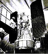
NIMBUS is a NASA program to develop observation systems meeting the research and development requirements of atmospheric and Earth scientists.
The Nimbus satellites, first launched in 1964, carried a number of instruments:
microwave radiometers, atmospheric sounders, ozone mappers, the Coastal
Zone Color Scanner (CZCS), infrared radiometers, etc. Nimbus-7, the last
in the series, provided significant global data on sea-ice coverage, atmospheric
temperature, atmospheric chemistry (i.e. ozone distribution), the Earth's
radiation budget, and sea-surface temperature.
TOMS instrument aboard the NIMBUS satellite was able to map the areal extent of the phenomenon known as the Ozone hole.
The project objectives were to provide improved photographs of local cloud conditions by an automatic picture transmission (APT) system, and to evaluate an advanced vidicon camera system for daylight coverage and a high-resolution infrared radiometer system for night-time cloud-cover observation.
Nimbus missions have sent back over 27,000 high-resolution photos; at
its height they photographed 70 percent of the world each day. The APT
system supplied daytime photos to more than 60 low-cost ground stations.
Radiometer photos were remarkably clear and covered a 12,500-square mile
area.