Earth Observing-1 (EO-1) is the first satellite in NASA's New Millennium Program Earth Observing series. The Earth Observing Missions will work to develope and test new satellite imaging techniques. For more information visit the EO-1 homepage.   Earth Observing - 1  

Temporal Resolution

EO-1 was launched on November 21, 2000 from

Vandenberg Air Force Base. EO-1 will follow the same orbit as Landsat 7,

imaging the Earth every 16 days. The two satellites are calibrated to image 

the same areas so comparisons can be made.

back to top

Sensors
 
Advanced Land Imager

(ALI)

Mimics Landsat 7 with three extra bands three additional bands covering 0.433-0.453, 0.845-0.890, and 1.20-1.30 µm.

Spectral and Spatial Resolution
Band Wavelength (µm) Resolution
MS-1 .433-.453 30 meters
MS-1 .450-.510 30 meters
MS-2 .525-.605 30 meters
MS-3 .630-.690 30 meters
MS-4 .775-.805 30 meters
MS-4 .845-.890 30 meters
MS-5 1.20-1.30 30 meters
MS-5 1.55-1.75 30 meters
MS-7 2.08-2.35 30 meters
Pan .480-.680 10 meters
 
Atmospheric Corrector

(AC)

  • Spectral coverage of .85-1.5 µm bands
  • Using the Atmospheric Corrector enables more precise predictive models to be constructed for remote sensing applications.
 
Hyperion

Hyperspectral Imaging Instrument

  • 220 spectral bands (from 0.4 to 2.5 µm) with 30 meter resolution
  • 7.5 km by 100 km land area per image and provide detailed spectral mapping across all 220 channels with high radiometric accuracy
  • The Hyperion Sensor was developed by TRW as a 21st Century Tool for Resource Management.
 back to top
Instrument Information
Diagram taken from: NASA EO-1 - Advanced Land Imager
 
 back to top
Sample EO-1 Imagery
 

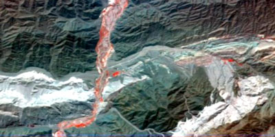
Hyperspectral image of a mountainous region of Argentina taken on December 1, 2000. Red colors show areas of new spring growth. One of the unique aspects of the Hyperion Instrument on EO-1 is it's ability to "pull out" spectral features in unprecedented detail.~~Spaceflight Now

Image taken from Spaceflight Now News.

Argentina
 back to top
Data Distribution
 
USGS EROS Data Distribution-Distributed Active Archive Center

NASA's Distributed Active Archive Center-List of all Archiving Centers for NASA data

 
 back to top
EO-1 Links
 
NASA's Earth Observatory-Full description of EO-1 sensors along with pushbroom vs. whiskbroom configuration

Spacedaily.com-News report on the Hyperion Sensor

USGS-Chart of comparisons between Landsat 5, Landsat 7, and EO-1

Evaluation of ALI and Hyperion Sensors from the University of Arizona

Spaceflight Now News-article on the calibration of Hyperion over the salt lake of Lake Frome in Southern Australia

 
 back to top
References
 
Information on this page was attained from the following sources:

The Landsat mission (http://eo1.gsfc.nasa.gov)

Spaceflight Now (www.spaceflightnow.com/news/n0012/23eo1first)

Kiefer, Ralph W. and Lillesand, Thomas M. Remote Sensing. New York: John Wiley & Sons, Inc., 2000


back to top
 
Lithosphere Homepage