IKONOS-2 was launched on September 24, 1999 becoming the first commercial satellite to provide high-resolution imagery at 1 meter resolution. Developed by Space Imaging, the system is capable of directing data collection in both cross-track and along-track methods, enabling the acquisition of mosaics in one pass. This makes IKONOS-2 a viable alternative to high-altitude aerial photography. IKONOS-2  

Temporal Resolution

IKONOS-2 occupies a 681-km sun-synchronous orbit with a descending

nodal crossing time of 10:30 a.m. The satellite has a revisit time of 2.9 days at 1-meter resolution and

1.5 days at 1.5-meter resolution. This high-resolution satellite is capable of 12-meter horizontal and

10-meter vertical accuracy with no ground control and 2-meter horizontal

and 3-meter vertical accuracy with ground control.

back to top

Spectral and Spatial Resolution of IKONOS-2

Band

Spectral range (µm)

Spatial resolution (m)

1 (Blue)

.450 - .520

4

2 (Green)

.520 - .600

4

3 (Red)

.630 - .690

4

4 (Near IR)

.760 - .900

4

Panchromatic

.450 - .900

1

back to top

Applications of IKONOS-2 Imagery

 
IKONOS-2 high resolution imagery, frequent revisit times, high accuracy levels, and combination of along-track and cross-track viewing methods create imagery that is useful in many applications:
   
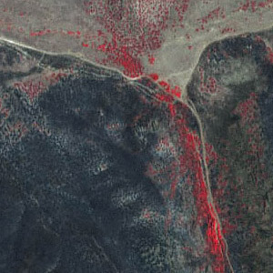
Morning Dove Wildfire, Utah
Municipal Planning, Analysis, and Mapping-Space Imaging News Release on Applications

Telecommunications-Satellus

Space Imaging - Applications

ESRI-IKONOS Applications and Samples

Global GeoScience IKONOS Applications and Imagery

Integrated Geoscience Inc.- Applications of IKONOS

ArcNews Online-Esri site, New Source of GIS Data

Eurimage-Ikonos product information and data

CARTERRA Forestry Application image - Morning Dove Wildfire, Utah

Four-meter, false color, near-infrared image acquired from Space Image Inc.

Dark black areas show damage caused by the fire, while bright red shows healthy vegetation.

back to top
Technical Information About the

IKONOS-2 Satellite

   
Eastman Kodak Company - Remote Sensing Camera

Educational Site-University Waterloo, Ca - IKONOS Camera Specs

IKONOS Pushbroom Imaging System

 
back to top
Data Distribution
 
Space Image Inc. Plangraphics - Describes Types of Imagery
ImStrat Corporation Creative Delphi2 Technologies
NPA Satellite Mapping and Exploration Computa Maps
Global GeoScience Integrated Geoscience Inc.
 
   
back to top
 
Information on this page was attained from the following sources:

Eurimage-IKONOS (www.eurimage.com/Products/ikonos_menu.html)

Space Image Inc. (www.spaceimaging.com/carterra/applications/default.htm#)

Kiefer, Ralph W. and Lillesand, Thomas M. Remote Sensing. New York: John Wiley & Sons, Inc., 2000