STUDYING VOLCANOES
WITH
REMOTE SENSING
![]()
Satellite Platforms

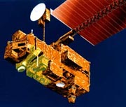
ASTER (Advanced Spaceborne Thermal Emission and Reflection
Radiometer) is an imaging instrument that is flying on Terra,
a satellite launched in December 1999 as part of NASA's Earth
Observing System (EOS). ASTER will be used to obtain detailed maps of land
surface temperature, emissivity, reflectance and elevation. The EOS platforms
are part of NASA's Earth Science Enterprise,
whose goal is to obtain a better understanding of the interactions between
the biosphere, hydrosphere, lithosphere and atmosphere.

Spaceborne Imaging Radar-C/X-Band Synthetic Aperture Radar (SIR-C/X-SAR)
is a joint U.S.-German-Italian project that uses a highly sophisticated imaging
radar to capture images of Earth that are useful to scientists across a great
range of disciplines. The instrument was flown on two flights in 1994. One was
on space shuttle Endeavour on mission STS-59 April 9-20, 1994. The second flight
was on shuttle Endeavour on STS-68 September 30-October 11, 1994.

The third operational satellite in NOAA's geosynchronous
weather satellite system. The satellite was designed to sense meteorological
conditions from a fixed location above the Earth, and to provide this data to
operational forecasters and private interests on the ground.
This web page
is by
Darsana and Mark
Salem State Collage Geography Students
Salem State Digital Geography Lab
Graphics and write-ups about each platform
provided by the respective web page.