Using Remote Sensing for
Ocean and Sea Floor Mapping
Summary: Mapping the sea and ocean floors are used for several different processes and to gain further information on the ocean and sear floors. The use of Side Scan Sonar and Radar are common practical uses to map the ocean and sea floor bottoms. The high resolution seismic resolution allows detail mapping and profiling of sediment size and distribution for further observations and ocean studies. Another application of mapping the ocean and sea floors is by altimetry. By mapping the altitude of the satellite above the ocean surface, this gives us a good idea of the sea surface topography.
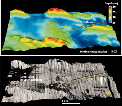
Maps of the sea-floor geology identify the locations where fine-grained sediment and associated contaminants accumulate. Remote-sensing techniques such as side-scan sonar and high-resolution seismic reflection profiling allow detailed mapping of the texture and distribution of sediment types on the sea floor on a regional basis. These maps illustrate that sediment texture and other bottom features are patchy and that major changes occur over a wide range of spatial scales. The variability is due to the irregular bottom topography, past and present sources of sediment, and the processes causing transport. Maps show the location and extent of erosional and depositional environments and provide a regional context for the interpretation of bottom samples and benthic observations. Fine-grained sediments typically indicate areas of sediment accumulation; coarse-grained sediments or boulders define areas where the sediments are scoured and winnowed by currents.
For additional information from the USGS using Side Scan Sonar, please use the following links below:
USGS Mapping the Sea Floor page. http://marine.usgs.gov/fact-sheets/fs172-97/mapping.html
Sustainable sea explorations with the USGS home page, http://sustainableseas.noaa.gov/missions/channel2/background/sonar.html
Use of Satellite Radar Altimetry to Map the Ocean Floor
Until recently, mapping the ocean floor was the domain of marine surveys. Though these produce accurate data, only some areas of the ocean have been mapped to date, often there are large gaps between the sonar swaths and it is an expensive and time consuming task. In recent years, altimetry data from US and European satellites have become available to scientists and the public in general. These have allowed global sea floor mapping that has provided a wealth of new information. The information derived is of value to a wide range of users, but researchers of global tectonics now have a new source of data. It will aid not only in identifying numerous new tectonic features but also in understanding the processes that have been creating and destroying oceans and continents for billions of years. By mapping the altitude of the satellite above the ocean surface, this gives us a good idea of the sea surface topography.
For more information on mapping the ocean floor using satellite radar altimetry to map the ocean floor, please click on the additional link http://www.globalserve.net/~wallace1/tectonics/webpres/
Additional Links for Satellite Atrimetry by NOAA:
Stennis Space Center (MS), Naval Research laboratory research involving mapping and charting the ocean floor. http://postoffice.nrlssc.navy.mil/mappingsciences/index.htm
Collaboration with NOAA and the development by the Ocean Remote Sensing Division using acoustic and electromagnetic remote sensing for oceanic floor research. http://www1.etl.noaa.gov/
The information on this web page was obtained from web pages reviewed by the webmaster from the National Oceanic and Atmospheric Administration (NOAA) Coastal Services Center, the United States Geological Society (USGS), and Global Techtonics Student Web Page from Emporia State University (GLOBALSERVE). None of the information is from original research or conclusions from the webmaster.