| Contents
SeaWinds |
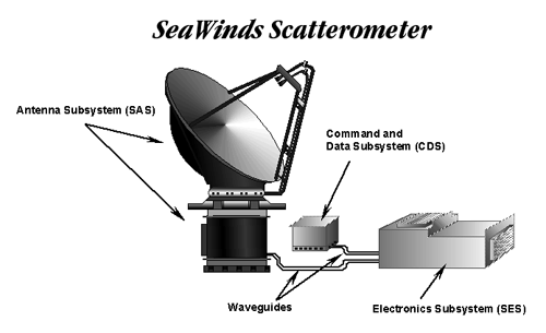
The SeaWinds scatterometer consists of the Electronics Subsystem, the Antenna Subsystem, and the Command and Data Subsystem. The Electronics Subsystem (SES) contains a transmitter, receiver and digital signal processor. It generates and sends high radio frequency waves to the antenna. The Antenna Subsystem (SAS), transmits the signal to the Earth's surface as energy pulses. The return signal or backscatter is routed by the antenna to the SES. A rough ocean surface returns a stronger signal because the waves reflect more of the radar energy back to the scatterometer antenna. A smooth ocean surface returns a weaker signal because less of the energy is reflected. The SES converts the signals into digital form for data processing. The Command and Data Subsystem (CDS) links the command center on the ground, the spacecraft and the scatterometer. For precise positioning on the Earth the CDS collects for each pulse the antenna rotational position, spacecraft time, and an estimate of the spacecraft position.
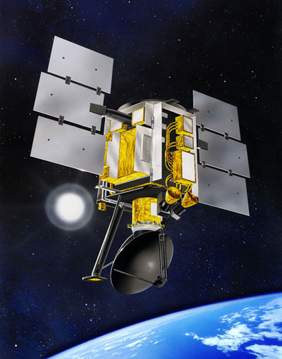
The SeaWinds instruments fly on the ADEOS-I, the ADEOS-II and the QuikSCAT satellites. Only the QuikSCAT is still operational. The orbital period is 102 minutes. The ADEOS (Advanced Earth Observing Satellite) was the first international space platform dedicated to Earth environmental research developed and managed by the National Space Development Agency of Japan (NASDA). ADEOS-I launched on August 17, 1996 into a sun synchronous sub-recurrent orbit of 100.8 minutes at an altitude of approximately 830 km and with an equator angle of 98.625 deg. ADEOS-I failed in June 1997. ADEOS-II flies the same specifications. ADEOS-II was launched on December 14, 2002 but ADEOS-II, also known as MIDORI-II also failed (went silent) after an anomaly was detected in the satellite on October 25 , 2003. NASA's QuikSCAT was lofted into space on 6/19/99 maximum altitude of about 800 kilometers (500 miles) above Earth's surface. The SeaWinds on QuikSCAT mission was a "quick recovery" mission to fill the gap created by the loss of data from the NASA Scatterometer (NSCAT), when ADEOS-I lost power in June 1997, before ADEOS-II was launched. As ADEOS-II has also failed the only SeaWinds instrument currently functioning is aboard the QuikSCAT satellite.
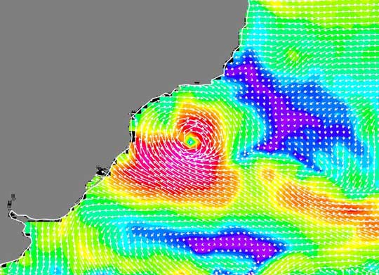
SeaWinds scatterometer data is available from the Physical Oceanography Distributed Active Archive Center (PODAAC), (http://podaac.jpl.nasa.gov/index.html). A variety of ocean vector winds products are available derived from ongoing SeaWinds on QuikSCAT data as well as finite datasets from ADEOS-II and NSCAT. The image below shows the first hurricane ever recorded in the South Atlantic captured by QuikSCAT and its Seawinds instrument. The white arrows representing wind speed and direction are superimposed on the color image of wind speeds.
First hurricane ever recorded in the South Atlantic March 29, 2004
Resources
QuikSCAT and SeaWinds main information site
|
|
|---|---|---|
|
Web Publications Dr. Young's Homepage Geography Department Salem State College
updated April 28, 2004 |
||