![]() GOES
Satellites
GOES
Satellites ![]()
Home Hurricanes GOES Satellites Images Links
This information was taken from:
GOES-8 and GOES-10
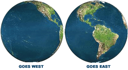
The United States normally operates
two meteorological satellites in geostationary orbit over the equator. Each
satellite views almost a third of the Earth's surface: one monitors North and
South America and most of the Atlantic Ocean, the other North America and the
Pacific Ocean basin. GOES-8
(or GOES-East) is positioned at 75 W longitude and the equator, while GOES-10
(or GOES-West) is positioned at 135 W longitude and the equator. The two
operate together to produce a full-face picture of the Earth, day and night.
Coverage extends approximately from 20 W longitude to 165 E longitude. This
figure shows the coverage provided by each satellite.
The main mission is carried out by the primary instruments, the Imager and the Sounder. The imager is a multichannel instrument that senses radiant energy and reflected solar energy from the Earth's surface and atmosphere. The Sounder provides data to determine the vertical temperature and moisture profile of the atmosphere, surface and cloud top temperatures, and ozone distribution.
Other instruments on board the spacecraft are a Search and Rescue transponder, a data collection and relay system for ground-based data platforms, and a space environment monitor. The latter consists of a magnetometer, an X-ray sensor, a high energy proton and alpha detector, and an energetic particles sensor. All are used for monitoring the near-Earth space environment or solar "weather."
This information was taken from:
http://coastwatch.glerl.noaa.gov/goes/goes-info.html