Dangers of Volcanic Ash
Travel Safety Threat
Damage in Flight
Damage on the Ground
North Pacific Air
Travel
Ring of Fire
Volcano Ground Observatory
Aircraft/Pilot Limitations
Remote Sensing Detection
GOES-Visible/Thermal IR
NOAA-AVHRR
EOS AURA -MLS/TES/OMI
Monitoring
and Warning
ICAO
WMO/NOAA
VAAC
ATC
Air Carrier Operation
Flight Crew Advisories
METAR
PIREPS
SIGMETS
References
Home
|
|
Commercial jet aircraft carrying thousands of passengers and
millions of dollars in cargo, in a daily routine, pass over areas hundreds
of volcanoes that are capable of sudden explosive eruptions
as they travel through the world's busy air traffic corridors. More than
half of the world's active volcanoes above sea level lie within an area of
high volatility known as the "Ring of Fire". This arc stretching
from the country of New Zealand, along the eastern edge of Asia, north
across the Aleutian Islands of Alaska, and south along the co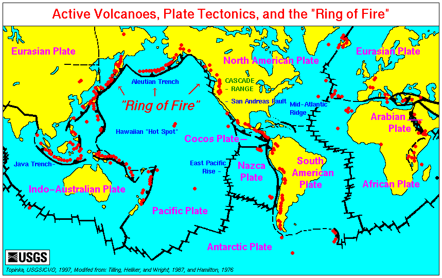 ast of North
and South America is an area of high density commercial air traffic. In addition, USGS
notes that on an average of 4 days per year in the North Pacific
region (segment of the "Ring of Fire"), volcanic ash is present above
30,000; most large jet aircraft cruise within an altitude range
between 30,000- 43,000 ft. (image to the right- link to map of world's volcanoes ) ast of North
and South America is an area of high density commercial air traffic. In addition, USGS
notes that on an average of 4 days per year in the North Pacific
region (segment of the "Ring of Fire"), volcanic ash is present above
30,000; most large jet aircraft cruise within an altitude range
between 30,000- 43,000 ft. (image to the right- link to map of world's volcanoes )
In response to problems caused by volcanic
activity, the World Organization of Volcano Observatories (mission
statement) was established in 1981 where scientists work
collaboratively in sharing their findings with others. There are three such
observatories bordering and within the Pacific Rim that play a vital role in
seismic monitoring of their respective regions of the "Ring of
Fire"; they are the Alaska Volcano Observatory (AVO),
the Russian Academy of Science's Kamchatkan Volcanic Eruptions Response
Team (KVERT)
and the Hawaiian Volcano Observatory (HVO).
Yet ground-based monitoring stations do not
provide stand alon e support and reliability in forecasting and tracking volcanic activity.
In addition, dangerous and costly encounters with volcanic ash happen
because ash clouds are difficult for flight crews to distinguish from ordinary
clouds due to restricted nighttime visibility, inclement weather and
deficiencies of aircraft radar. Airliners to date are equipped with a
forward-looking, onboard radar system but this is primarily a weather radar system
designed to display storm cells in intensities of green, yellow
and red being the most severe; however, it does not have the capability,
nor was it designed to
adequately, if at all, display volcanic ash. e support and reliability in forecasting and tracking volcanic activity.
In addition, dangerous and costly encounters with volcanic ash happen
because ash clouds are difficult for flight crews to distinguish from ordinary
clouds due to restricted nighttime visibility, inclement weather and
deficiencies of aircraft radar. Airliners to date are equipped with a
forward-looking, onboard radar system but this is primarily a weather radar system
designed to display storm cells in intensities of green, yellow
and red being the most severe; however, it does not have the capability,
nor was it designed to
adequately, if at all, display volcanic ash. |