Remote
Sensing |
This image depicts a hurricane tracking chart for the the Atlantic Ocean PREDICTION OF HURRICANES "Hurricanes and the conditions required for their formation are large scale phenomena which can be observed very well using remote sensing. Wind speed, sea surface temperature (SST), sea level and thermocline depth can either be measured or inferred from remotely sensed data. Using this information with surface measurements of atmospheric pressure and additional measurements of wind speed and other conditions taken from reconnaissance planes which fly through the storm, scientists attempt to predict the path and intensity of the storms". (More Info on this topic)
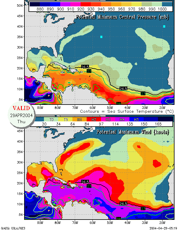
This image depicts hurricane intensity HURRICANE INTENSITY "Using data from remote sensing satellites, researchers at the University of Colorado at Boulder are investigating a key factor that can be used in predicting the extent of a hurricane's fury.A hurricane's passage over a warm ocean eddy or current has been linked to a marked intensification of hurricane winds." (More Info on this topic)
This is an example from NOAA'S SLOSH program HURRICANE STORM SURGE AND LAND COVER ANALYSIS "The Sea, Lake, and Overland Surge from Hurricanes (SLOSH) model was developed by the National Oceanic and Atmospheric Administration (NOAA) National Weather Service (NWS). The model identifies the potential surge zones associated with the various storm categories on the Saffir-Simpson hurricane scale" (More Info on this topic)
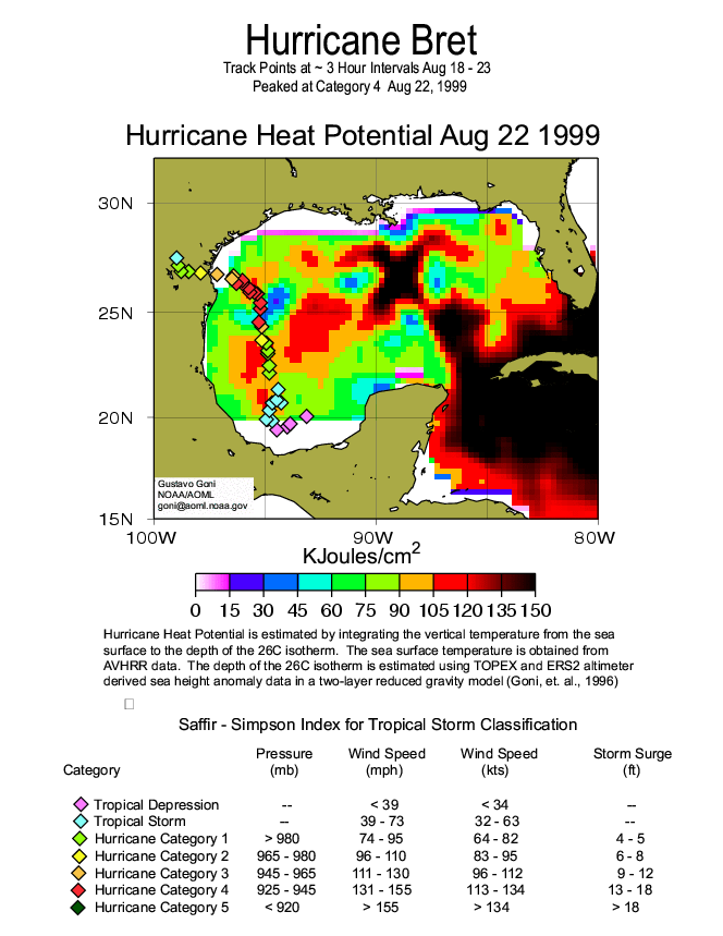
This is an image depicting Hurricane Brett's heat potential TROPICAL CYCLONE HEAT POTENTIAL FROM ALTIMETRY "The intensification of tropical cyclones involves a combination of different favorable atmospheric conditions such as atmospheric trough interactions and vertical shear, which lead to good outflow conditions aloft. As a result of this, inflow conditions in the near-surface layer are enhanced. Clearly, as this process continues over the scale of the storm, the upper ocean provides the heat to the atmospheric boundary layer and the deepening process. In this scenario, the upper ocean thermal structure has been thought to be a parameter that only played a marginal role in tropical cyclone intensification" (More Info on this topic)
Lockeed WP- 3D Orion, this airplane is used for meterological purposes MEASURING HURRICANE SEA SURFACE WIND "A research instrument the size of a 27-inch television set that is carried aboard NOAA Hurricane Hunter aircraft has been determined to be the most accurate and reliable remote sensing device available for measuring hurricane force winds at the sea surface. The results come from a study by NOAA scientists and the University of Miami’s Cooperative Institute for Marine and Atmospheric Sciences" Eric Uhlhorn of the University of Miami’s Cooperative Institute for Marine and Atmospheric Sciences, one of NOAA’s 11 joint and cooperative institutes, and Peter Black with the NOAA Hurricane Research Division, have determined that the stepped-frequency microwave radiometer (SFMR), an instrument carried on NOAA hurricane hunters, is a top performer in measuring hurricane force winds at the sea surface" .(More Info on this topic)
|