|
Overview
|
|||||
| Contents
Overview |
Ocean surface winds are a key element of global climate
studies.
Global monitoring of the ocean surface winds is of
vital importance to the scientific community.
While instruments on buoys and ships provide measurements of the
surface wind vectors, their coverage is insufficient to provide a
global wind field map.
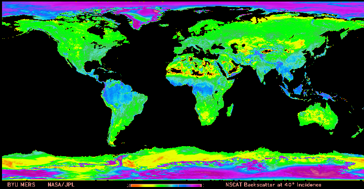
Satellite based sensors can provide global coverage in a reasonable time period. Sensors operating in microwave frequencies can measure the surface wind vector during nighttime and cloudy conditions, and greatly increase the quantity of surface observations. Both active radar and passive radiometer microwave sensors have been shown capable of determining the ocean surface wind speed. Active microwave instruments can be used to derive the wind direction. Radiometer systems are capable of determining the wind direction using polarimetric and multi-look observations. Development and refinement of instrumentation and algorithms for ocean surface wind retrieval is ongoing in both the active and passive areas. There are currently three sensors collecting data from which to derive ocean surface wind direction and speed. The Special Sensor Microwave Imager (SSM/I) is a passive sensor, designed to record exisiting microwave emissions from the ocean surface. In contrast to the SSM/I, the other two functioning sensors use active radar systems to produce the microwave backscatter from which sea wind data is derived. The Wind Scatterometer is one of the instruments flying aboard the European Space Agency's ERS-2 satellite. The SeaWinds scatterometer is an active microwave radar sensor designed specifically to measure surface wind speed and direction. There is additional historic data available from retired sensors such as the Wind Scatterometer on ERS-1and the NSCAT scatterometer on ADEOS I and the SeaWinds scatterometer on ADEOS-II. The pages within this site provide information on the sensors and the satellites that are currently producing data about ocean winds. Each page will have resources listed as below for more information. Resources http://manati.wwb.noaa.gov/doc/oceanwinds1.html NOAA Marine Observing Systems Team ocean surface winds page http://www.jpl.nasa.gov/earth/ocean_motion/ocean_motion_index.cfm Jet Propulsion Laboratory of California Institute of Technology ocean studies page http://www.esa.int/export/esaSA/GGGWBR8RVDC_earth_0.html European Space Agency ERS 1 and 2 satellites page Jet Propulsion Laboratory of California Institute of Technology ocean winds page
|
||||
|---|---|---|---|---|---|
Web Publications Dr. Young's Homepage Geography Department Salem State College
updated April 28, 2004 |
|||||