|
|
|
|
7 July 2003
7 July 2003
7 July 2003 3 images above from http://www.esa.int/export/esaSA/SEMO75XO4HD_earth_0.html
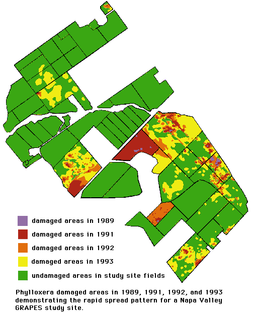
Here we see an early image of damaged areas in one area of Napa Valley included in the GRAPES study. from
http://geo.arc.nasa.gov/sge/grapes/grapes.html
Below are three aerial photography false color infrared images taken in the mid to early 1990's showing phylloxera infested areas. Red represents healthy vegetation and near bare soil appears cyan (blue-green). from http://geo.arc.nasa.gov/sge/grapes/aircraft.html
1993: 2m pixel resolution image
The block in the middle of this image was recently replanted, so it contains very little vine growth yet. All of the blocks in this image were infested with phylloxera and show mottled patterns indicating damaged areas within the blocks.
1994: 5m pixel resolution image The spatial resolution of this image was coarser than in 1993. The image has a similar appearance to the one above, but the damaged areas have spread and two blocks along the top of the image are now cyan, since the vines there have been pulled out.
1995: 3m pixel resolution image This image shows more blocks have been pulled out and those that remain may be pulled by now. In contrast, the blocks in the middle of the image are well grown and the lower one has full canopy cover.
More images can be seen at NASA's GRAPES page. |
|
Pamela O'Brien Salem State College, MS in Geo-Information Science Professor S. Young GGR909 Remote Sensing Last modified: December 15, 2003 |