|
|
|
|
Many different types of remote sensing techniques have been aiding scientists and wine growers in gathering data about vineyards in ways that conventional monitoring do not allow. Below are brief descriptions of the sensors employed in this endeavor.
IKONOS One
of the more commonly used sensors used for imaging vineyards is on the IKONOS satellite.
The work icon in Greek means “image.”
IKONOS was built by Lockheed Martin Commercial Space Systems and is a commercial remote sensing satellite owned by a company called
Space Imaging. The camera was built
by the Eastman Kodak company and Raytheon built the image processing and
communications elements.
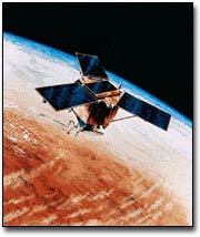
image from http://www.kodak.com/US/en/government/heritage/ikonos.shtml IKONOS
was launched in 1999 has been delivering data since early 2000.
IKONOS is the first commercial high spatial resolution remote sensing
satellite with a 1-meter resolution. IKONOS
data records 4 channels of multispectral data at 4 meter resolution and one
panchromatic channel with 1 meter resolution. This means that IKONOS was
the first commercial satellite to deliver near photographic high resolution
satellite imagery of anywhere in the world. IKONOS has both
cross and along track viewing instruments which enable flexible data
acquisitions and frequent revisiting capabilities - 3 days at 1 meter resolution
and 1 to 2 days at 1.5 meter resolution. info
derived from http://www.infoterra-global.com/ikonos.htm and http://www.terrainmap.com/rm17.html
More detail on IKONOS specifications can be viewed at Space Imaging Southeast Asia Co., Ltd. (SISEA.)
IKONOS orbit Paths image from http://www.sisea.co.th/kionos/characteristics.html QuickBird QuickBird
is another commercial satellite producing images used by wine growers to monitor
their vineyards. QuickBird is owned
and operated by a company called Digital Globe. It was built by Ball Aerospace & Technologies Corp, Kodak
Eastman and Fokker Space.
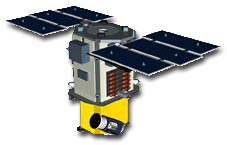
QuickBird image from http://www.kodak.com/US/en/government/heritage/quickbird.shtml QuickBird was launched in 2001 at an altitude of 450km. It has a sun synchronous 98 degree inclination. It collects panchromatic data at 61 cm (2 ft) and multispectral data at 2.44-m (8-ft.) More QuickBird specifications can be found at the website for DigitalGlobe.
http://www.digitalglobe.com/gallery/index.shtml
During NASA's CRUSH project, almost 200 linear km of flightlines were established over vineyards in California's premiere North Coast winegrowing region (primarily Napa and Sonoma Counties). Digital photography was acquired on 31 July and 01 August 1997 by Crop Image (Salinas CA) using an ADAR System 5500 (Positive Systems, Whitefish MT). The CCD-based system recorded 8-bit imagery in the following spectral channels: blue (450-540 nm), green (520-600 nm), red (610-680 nm) and near-infrared (760-1000 nm). From flight altitude of 4300 m above ground level, spatial resolution was 2 meters per pixel. Each image frame was 1000 x 1500 pixels (2 x 3 km). All images were collected under clear skies within two hours of solar noon. An image frame containing Mondavi's Carneros vineyard and test block was selected for post-processing. First, a Normalized Difference Vegetation Index (NDVI) [(NIR-red / NIR + red)] was derived for each pixel (Tucker 1979). Unsupervised classification based on the Iterative Self-Organizing Data Analysis (ISODATA) algorithm (Duda and Hart, 1973) was then used to assign each pixel to one of 12 groups, based on NDVI value. In a previous study Johnson et al. (1996) reported that this simple approach yielded a reasonably strong relationship (r2=0.76) to vine pruning weights (an indirect measure of canopy density) over two growing seasons. Each group was assigned a different color on the output "classified NDVI" image to enhance visual interpretation. A hardcopy color print of the classified NDVI image was taken to the field in early August 1997 to roughly subdivide the test block into three segments of approximately equal area, representing three levels of density ("vigor"): high, medium and low. Seven groups of five consecutive (within-row) vines from throughout the field were selected and flagged: two groups in the high vigor area, two groups (moderate) and three groups (low). Subsequent pre-harvest revision of the segment boundaries resulted in the following distribution of sample vine groups: two (high), one (moderate) and four (low). from http://geo.arc.nasa.gov/sge/crush/ERIM.html#methods Images of these photographs can be viewed on the Images page of this web site.
UAV Helios Prototype image from http://www.dfrc.nasa.gov/gallery/photo/Helios/Medium/index.html Unmanned Aerial Vehicles are one of the more recent technologies being used in remote sensing to produce imagery for use in agriculture. The high altitude unit above is a solar powered propeller UAV with the capability to linger over an area. This increase in dwell time provides higher quality, high resolution MSS images and can decrease atmospheric interference as it can linger until clouds, haze or moisture clear. The Helios was developed by NASA's Environmental Research Aircraft and Sensor Technology (ERAST) and AeroVironment, Inc. In addition, a small UAV is under development by RnR Products (Milpitas, CA) MLB (Palo Alto, CA) and Lockheed Martin, which has high spatial resolution, about 20 cm. It was used in August 2003 to collected red-green-blue and hyperspectral imagery above a large commercial vineyard in California. One of the goals of further developing this type of sensor is the potential of both more real-time delivery of data and more cost effective data production than other methods such as satellite data collection. For more detailed information with interesting images, please refer to the proceedings of the International Symposium on Remote Sensing of Environment, 2003 and the paper Collection of Ultra High Spatial and Spectral Resolution Image Data of California Vineyards with a Small UAV by LF Johnson, S Herwitz et al. at http://geo.arc.nasa.gov/sge/vintage/ISRSE_reprint.pdf. Ground Penetrating Radar (GPR)
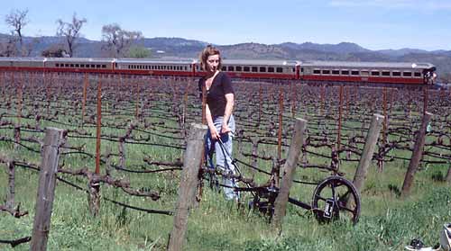
Hydrogeophysicist Susan Hubbard conducts field research between rows of grapevines at the Robert Mondavi Winery. She is dragging a surface geophysical device, called a ground penetrating radar, to map soil moisture in the vineyard. (Photo courtesy of Mike Kowalsky) The irrigation of vineyards can be a difficult process to manage in part because of the many geological variations within a small area. Soil moisture content in any agricultural endeavor is key to producing desired results. GPR can help to define soil moisture content in vineyards. More information at: http://www.coe.berkeley.edu/labnotes/1003/rubin.html |
|
Pamela O'Brien Salem State College, MS in Geo-Information Science Professor S. Young GGR909 Remote Sensing Last modified: December 15, 2003 |