|
|
|
|
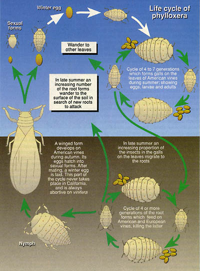
In the 1850’s a root louse called phylloxera arrived in California. This aphid like louse, which is native to southern and eastern US, was also unintentionally brought to France in 1860, and proceeded to spread to most areas of the world where grapes are grown. However, it wasn’t until much later, the late 1980s, that phylloxera began destroying commercial vineyards in California. Phylloxera
kills grape vines by living and feeding on the roots until they eventually die.
Perhaps one of the most difficult issues surrounding the phylloxera
problem is that there is no remedy. Infected
vines must be destroyed and the area replanted.
image from http://www.phylloxera.com.au/phylloxera/biologyandbehaviour.html
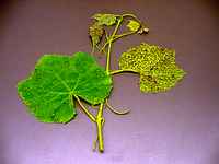
Historically
the only way to determine if vines were infected was to dig up the roots of
vines displaying early yellowing leaves an
image from http://ppdl.org/dd/id/grape_phylloxera-grape.html Aside from vine age, vigor and variety, factors such as soil type and drainage may dictate how long infected vines can survive. Infested vines can live longer in fertile, deep well-drained soil than in shallow soil with poor drainage. When heavier soils dry, they contract and crack leaving openings for the bugs to find their way into the root system. Thus, a finer textured soil like clay is more likely to have infested roots than lighter sandy soils. During
the 1993-1995 time period, NASA Ames Research Center ( Ecosystem
Science and Technology Branch) collaborated with the wine growers industry
and university partners to develop and transfer the use of remote sensing and
associated computerized technologies as a tool for vineyard managers to use in
addressing the phylloxera problem. from http://geo.arc.nasa.gov/sge/grapes/grapes.html They
program was nicknamed GRAPES Grapevine Remote
Sensing Analysis of Phylloxera
Early Stress. A slightly later NASA/Ames Ecosystem Science and Technology Branch (ECOSAT) collaboration with Robert Mondavi Winery (Oakville CA) and Wine Grow Consulting (Healdsburg CA) began in 1997 to evaluate the technical and economic feasibility of using airborne images to improve crop uniformity in winegrape harvest. In addition, ECOSAT teamed with TerraSpase Vineyard Mapping Services (Napa CA) to provide image-based data and information to clients in the greater North Coast region. This project was called Canopy Remote-sensing for Uniformly Segmented Harvest or CRUSH. Two-meter digital multispectral images were collected in late July 1997 by aircraft over vineyards in Napa and Sonoma Counties by partner CropImage (Salinas). NASA participation in the CRUSH project was sponsored by the Ames Commercial Technology Office under the Commercial Technology Project Fund. The Fund is intended to stimulate the transition of Ames technology to the private sector. from http://geo.arc.nasa.gov/sge/crush/crush.html
CRUSH RESULTS Technology Demonstration: Mondavi Winery produced wines of different character from different portions of the study field. In addition, for the first time ever, "reserve" wines (highest quality and value) were produced from sections of the study field.
Technology Transfer: Ames scientists assisted Terra Spase Consulting in implementing value-added processing on their in-house system. Terra Spase was able to process and market the resulting imagery for evaluation purposes to about 25 winegrowing clients in Napa and Sonoma Counties. from http://geo.arc.nasa.gov/sge/crush/crush.html
PUBLICATIONS "Of Pixels and Palates: Can Geospatial Technologies Help Produce a Better Wine?" Johnson et al., Proceedings 1st Int'l. Conf. Geospatial Information in Agriculture and Forestry, June 1998. "Vine and Vigor: Art and Science in the Vineyard." Daniel Bosch, Precision Farming, Dec. 1997. "Building an Image." California Farmer, September 1997. from http://geo.arc.nasa.gov/sge/crush/crush.html
|
|
Pamela O'Brien Salem State College, MS in Geo-Information Science Professor S. Young GGR909 Remote Sensing Last modified: December 15, 2003 |