Home Remote Sensing Programs Australia New Zealand Links
Below is a collection of images taken from various sources. These are just a few examples of how remote sensing is currently being used in the Austral Realm. For more information on any of these images just click the highlighted areas in the description to take you to the web pages they came from.

The Austral Realm at Night
This shot was taken to show a night image of the realm. From this image we can determine where the population is concentrated. This image was taken by the International Dark Sky Association (http://www.darksky.org/images/sat.html).
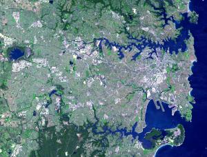
This simulated natural color ASTER image shows the Sydney metropolitan area as seen on October 12, 2001, and covers an area of 42 x 33 km. Inhabited for at least 50,000 years, Sydney was visited by Captain Cook in 1770, and later settled in 1788 by Captain Phillip and the First Fleet. Possessing two superb natural harbors (Botany Bay to the south and Sydney Harbor to the north), the city grew steadily. Currently it is the home of more than 4 million inhabitants from over one hundred countries.
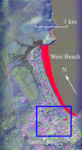
Thermal Infrared, Weri Beach, Australia
Decorrelation stretch of bands 5, 3 and 1 from NASA's Thermal Infared Multispectral Scanner (TIMS) displayed in red, green and blue respectively. Data were acquired in 1993 with a pixel size of 4m. Variations in color in the image are due to differences in the surface material while variations in brightness are due to difference in surface temperature. The red appearance of Weri beach indicates it is composed of silica (sand). In the top of the image notice how the Railroad track disappears as it passes through a tunnel. Click here to see an enlargement of the urban area (blue box) in which different roof compositions can be distinguished.

This is image is from NOAA's GOES-9 satellite. It shows cloud cover over Australia and images such as these are used in daily weather forecasts. For more on the national weather of Australia, click here.
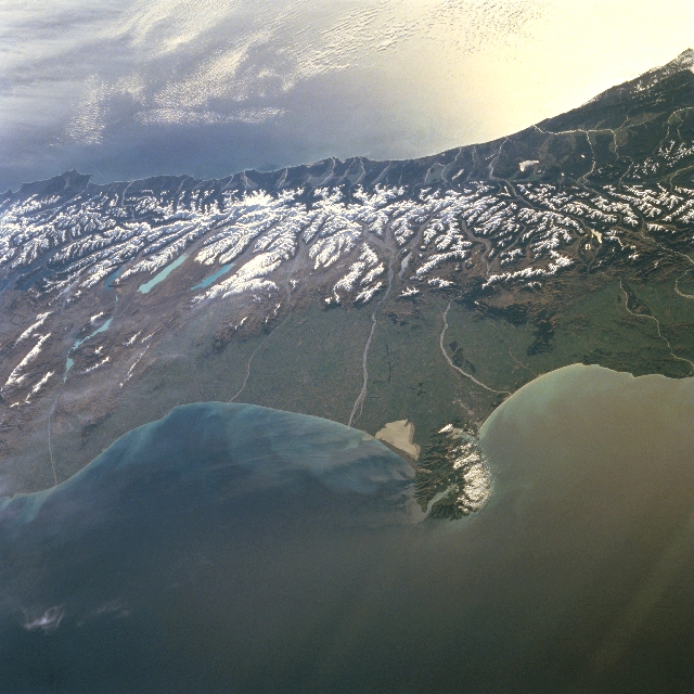
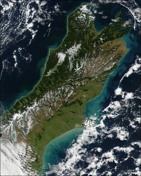
In this west-looking view, the snow-covered Southern Alps of central South Island, New Zealand can be seen. Running southwest to northeast along the western coast of South Island, the Southern Alps are rugged mountains made up of numerous peaks in excess of 9842 feet (3000 meters). Within the Southern Alps, there are over 3100 active glaciers. Evergreen woodlands dot the western coast and many glacial lakes are visible on the eastern slopes of the mountains. Just below the center of the image, the Canterbury Plain, the largest area of fertile, flat land in New Zealand, is visible. Braided rivers up to 16 miles (25 km) wide are discernible crossing the plain. The Banks Peninsula, formed following a violent eruption of two volcanoes, extends outward from the east coast into the Pacific Ocean. The peninsula is 35 miles (56 km) long and 25 miles (40 km) wide. The bright area off the west coast of the island is caused by sun glint off the waters of the Tasman
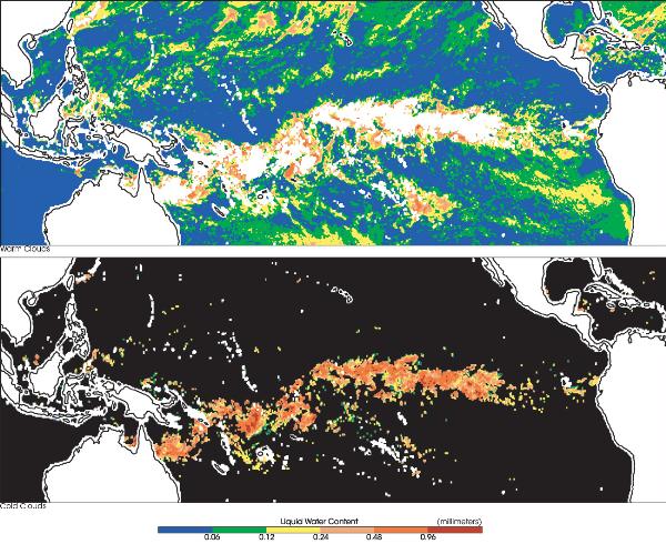
Warm and Cold Clouds Over New Zealand
Distribution of Warm Clouds and Cold Clouds in El Niño
Year, 1998
This image show typical average distributions of warm clouds (top image,
mostly in green) and cold clouds (bottom image, mostly in orange) for
January 1 to 3, 1998.
The top image shows a much greater distribution of warm clouds globally,
as compared with cold clouds in the bottom image. The units are in
millimeters of liquid water in clouds. Warm clouds tend to be thinner and
lower and precipitate a light warm rain. Cold clouds are thicker and
higher in the atmosphere, and produce larger raindrops. Analyses of images
like these with respect to sea surface temperature provide useful
information regarding the redistribution of warm clouds vs. cold clouds as
a result of global climate change.
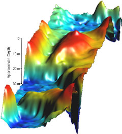
3D Surface Plot of Depth of Sydney Harbor
This image depicts the bathymetry (water depth) of a section of Sydney Harbor in Australia. It shows approximate depth as well as terrain features in the harbor.

Smoke from bush fires surrounding Sydney
A large phytoplankton bloom brightened the water around New Zealand on April 7, 2002. This true-color image was acquired by the Moderate-resolution Imaging Spectroradiometer (MODIS), flying aboard NASA's Terra satellite.
Image courtesy of NASA Visible Earth