Austral Realm Satellite and Remote Sensing Programs
Home Images Australia New Zealand Links
Various remote sensing programs (both private and public) are based throughout Australia and New Zealand. Below are short descriptions and links to centers, organizations and information concerning remote sensing applications in the Austral Realm. For more links to various Austral remote sensing programs click here.

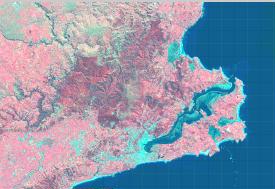
Australian Bathymetry and Topography
The Australian Center for Remote Sensing (ACRES) is a great resource for current remote sensing projects in Australia. It also includes an interactive map (see left) which allows you to arrange data layers of remotely sensed information to created your own maps.
SPOT Image of Landcover in the Otago Region
Remote Sensing and GIS for Forestry Assessment in the Otago Region
This site deals with forestry management in the New Zealand Otago region using remote sensing to assess techniques for forest monitoring and management.
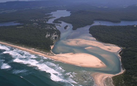
Lake Conjola, Australia
The Australian New Zealand Land Information Council website contains information about case studies utilizing remote sensing. There are a growing number of applications and services utilizing spatially-related data to provide business solutions in government agencies, business enterprises and ultimately, the community. A number of examples have been selected to illustrate some uses that are being made of spatially-related data.
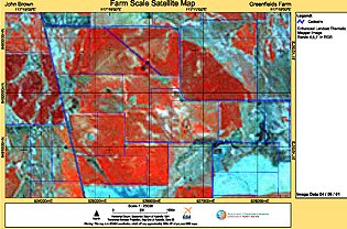
Farm Scale Satellite Map showing variability within crops, pastures and indicating areas of degradation.
The Department of Land Information in western Australia is an organization designed to provide increased access to government land and property information. They gather geospatial information from ground surveys, aerial photoography and satellites to produce a wide range of digital and hard copy products.

The vegetation history image for the southwest in western Australia.
CSIRO Mathematical and Information Sciences is Australia's Commonwealth Scientific and Industrial Research Organization. They are a scientific global research organization with a mapping and monitoring division. This division focuses on the analysis and processing of remotely sensed and other spatial data. They emphasize the analysis of long-term sequences of images to determine trends in land condition and the integration with related spatial data sets to predict areas at risk from degradation.
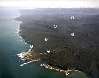
Waitutu Forest: terrace sequence.
Study plots are located on alluvial sites
(A, < 40m elevation), terraces 3–4 (80–100 m)
and terrace 6 (300 m).
The Manaaki Whenua Landcare Research center is an environmental research organization specializing in sustainable management of land resources optimizing primary production, enhancing biodiversity, increasing the resource efficiency of businesses, and conserving and restoring the natural assets of our communities. They run various research projects dealing with New Zealand's environment and utilizing remote sensing as part of this application.