INTRODUCTION
Siting
Wind Turbines
Remote Sensing
OVER SEA
Scatterometry
Satellites
Research Programs
OVER LAND
Doppler Radar
U.S. Radar Coverage
Research Programs
ON SITE
Mini-
SODAR
Research Programs
WIND POWER
Growth
in Wind Energy
Finding Strong Winds
Wind Atlases
Site Studies
Web site created
by
Paul Kelly
Graduate Student
Geo Information Science
Department of Geography
Salem State College
Salem, Massachusetts, USA.
E-mail comments and suggestions to pmkelly@prodigy.net.
Last updated 4/24/2002.
|
|
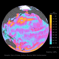 NSCAT
image of Pacific Winds, Sept. 1997 NSCAT
image of Pacific Winds, Sept. 1997
OVER
SEA
The following discussion focuses on scatterometry. However,
other space-based remote sensing systems have been used to track winds
over the ocean with varying success. These include detection of
passive microwave emissions and infra-red tracking of cloud and water
vapor movements. A brief, excellent discussion of these various
remote sensing techniques, along with scatterometry, was presented by
David Kilham in a 1999 workshop,
"Wind
Measurement from Space"
 .
(See sec. 4.4, p. 19, of the workshop report.) .
(See sec. 4.4, p. 19, of the workshop report.)
Scatterometry
[MERS at Brigham Young University has a
good introduction to scatterometery.]
Traditionally, data on winds over the
open ocean has had wide gaps, relying upon reports from ships at sea, bouys,
and coastal stations. Space-based remote sensing of winds has greatly
increased the available data over the 70 percent of earth’s surface that is
covered by water. The results have dramatically improved early detection
of severe storms. They
are also being incorporated into climate models. Relevant to wind energy
generation, this satellite data is now being integrated into wind atlases
prepared for coastal and island areas.
 Satellites use radar scatterometry to
estimate wind speed and direction over open water. The actual reflecting
(or “backscattering”) surface is ripples on the ocean surface. Small,
centimeter-sized waves, caused by wind, give back stronger
backscatter as the ocean surface roughens. Analysis of the data is complex
because, for individual ground resolution cells, there is no unique solution
for wind speed and direction. In one procedure, called point-wise wind
retrieval, possible solutions (based on multliple measurements made at
differing angles) are correlated, ranked in probability, and selected based
on best-fit with adjacent cells. The development of algorithms for
point-wise and field-wise wind retrieval is a subject of ongoing
research. Satellites use radar scatterometry to
estimate wind speed and direction over open water. The actual reflecting
(or “backscattering”) surface is ripples on the ocean surface. Small,
centimeter-sized waves, caused by wind, give back stronger
backscatter as the ocean surface roughens. Analysis of the data is complex
because, for individual ground resolution cells, there is no unique solution
for wind speed and direction. In one procedure, called point-wise wind
retrieval, possible solutions (based on multliple measurements made at
differing angles) are correlated, ranked in probability, and selected based
on best-fit with adjacent cells. The development of algorithms for
point-wise and field-wise wind retrieval is a subject of ongoing
research.
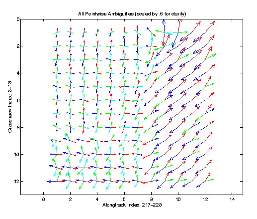
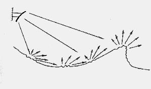
Illustration of possible wind vectors,
ranked as most probable: blue=1st, red=2nd, green=3rd, aqua=4th
MERS, Brigham Young University
Satellite Missions
The first space-based scatterometry experiments
were performed in 1973 and 1974 aboard Skylab.
In 1978,
SASS operated successfully for 3 months onboard NASA’s Seasat
satellite. The European
Space Agency launched a single-swath scatterometer on ERS-1,
and on ERS-2 in 1995.
In 1995 NASA’s dual-swath NSCAT
operated for 9 months on Japan’s ADEOS satellite.
When the ADEOS power system failed, NSCAT data had proven so
useful that plans for a follow-on mission were sped up, and SeaWinds
(with dual pencil-beams rather than earlier fan-beams) has now been
operating on the QuikSCAT satellite since 1999.
QuikSCAT was only designed for an operating life of 2 years. A similar SeaWinds scatterometer will fly on ADEOS-II, which
was originally scheduled to launch in February, but will now not fly
before November 2002.
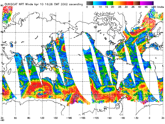
NOAA publishes a daily
global image of wind estimates from SeaWinds on QuikSCAT.
The SeaWinds systems have 25 to 50 km resolution
and cover 90 percent of the earth’s surface each day.
They estimate wind speed within 2 meters/second accuracy over a
range of 3 to 20 m/sec and wind direction within 20 degrees. Data from QuickSCAT are processed and distributed for weather
forecasting within 3 hours. Data
for scientific analysis are available within two weeks.
The ERS-2 Active
Microwave Instrument (in Wind Mode) is the other currently operative
satellite-based scatterometer, giving resolution and accuracy similar to
SeaWinds. However, AMI does
not give continuous wind data since it cannot operate in all modes
simultaneously .
Research
Programs
The
Microwave Earth Remote Sensing (MERS)
Laboratory at Brigham Young University is conducting research on wind
field models, point-wise quality assurance algorithms, and field-wise
wind retrieval.
The College of
Oceanic and Atmospheric Sciences at Oregon State University analyzes
near-surface wind speeds and directions measured by satellite-borne
radar scatterometers to provide essential insight into atmospheric
forcing of upper ocean processes and climatically important air-sea
interactions on many scales. Relevant research reports to include
"Orthographically Modified Winds," "Satellite
Observations of Wind Jets off Central American," and "Sampling Errors in Wind Fields Constructed from Single
and Multiple Scatterometer Datasets."
Continue
Top
of Page |